Skip to content
  • HOME
  • ABOUT MNICS
  • ABOUT MIFC
  • CONTACT US

MNICS.org

  • INCIDENT INFORMATION
    • Minnesota Incidents
    • Inciweb
  • PREDICTIVE SERVICES
    • Member Support
    • Weather
    • Fuels / Fire Danger
    • Outlooks
  • MNCC DISPATCH / NEK
    • Minnesota Interagency Coordination Center
    • Aviation
    • Intelligence
    • Equipment / Supplies
    • Overhead / Teams
    • Overhead – Single Resource
    • Crews
  • ADMINISTRATIVE
    • MNICS Coordination
    • Outreach Resources
    • Policy, Plans and Guides
    • Incident Business
    • Safety Management
    • Training
  • RESOURCES AND LINKS
    • Photo Galleries
    • Eastern Area Coordination Center
    • All Regional Coordination Centers
    • National Coordination Center
    • Firewise Minnesota
  • Calendar
MNICS.org

WELCOME TO MNICS

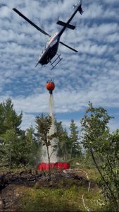
Our mission is to provide coordination, education and implementation of the Incident Command System in Minnesota and support fire and all-risk incidents in the nation.

RED FLAG WARNING ISSUED – 05.12.2026

Infographic image of a Minnesota county boundary map with red flag warning area shaded pink and a red flag banner image with white and yellow text all set in front of a light blue background.


2026 Minnesota Wildfire Academy

The MNICS partners are now accepting registration for the 2026 Minnesota Wildfire Academy.

Infographic cover page with a black and orange decorative background and image of the state of Minnesota, a man working with a chainsaw and the MNICS logo.

  • 2026 Minnesota Wildfire Academy Brochure
  • 2026 Minnesota Wildfire Academy Course Registration


2025 MNICS Annual Report

A cover page image with a night time wildfire scene, the MNICS logo in the upper right and the text Annual Report 2025 in the lower right.


News

  • Red Flag Warning Issued 05.12.2026 May 12, 2026
  • Counties added to spring burning restrictions May 1, 2026
  • Counties added to spring burning restrictions April 19, 2026

Current Preparedness Levels

  • Minnesota = 4
  • Eastern Area = 2
  • National = 2

Updated 05/12/2026

NIFC Predictive Services

National Significant Wildfire Potential Outlook
MN Fire Danger map

Current Conditions

Fire Danger

MN Fire Danger map

Burning Restrictions

MN Burning Restriction map
  • BIA
  • DNR
  • FS
  • FWS
  • HSEM
  • NPS
  • SFM
  • |
  • DISCLAIMER
  • ADMIN LOGIN
  • PRIVACY
  • CONTACT US