WELCOME TO MNICS

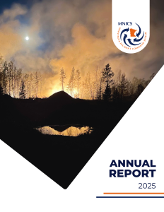
Our mission is to provide coordination, education and implementation of the Incident Command System in Minnesota and support fire and all-risk incidents in the nation.

Image of a topographic map with forest closure area defined by tan outlined area filed with tan hashtags, and the two fire areas shaded red with red and black outlines. An Eastern Area logos is embedded into the legend.

Camp House Fire Information

  • Size: 12,071 acres
  • Containment: 90%
  • Cause: Under investigation
  • Date discovered: 5.11.2025
  • Location: Brimson, MN
  • Camp House InciWeb Page

Jenkins Fire Information

  • Size: est. 16,089 acres
  • Containment: 78%
  • Cause: Human
  • Date discovered: 5.12.2025
  • Location: Southeast of Hoyt Lakes, MN
  • Jenkins Creek InciWeb Page

Munger Shaw Fire Information

  • Size: est. 1,259 acres
  • Containment: 95%
  • Cause: Under investigation
  • Date discovered: 5.12.2025
  • Location: Southeast of Cotton, MN
  • Munger Shaw InciWeb Page

Updated on 5.24.2025 at 11:45 a.m.


The 2025 Minnesota Wildfire Academy Registration is Now Open!

Infographic with an image of a firefighter using a chainsaw to cut a log.