

- Size: 21 acres
- Detected: June 4, 2021
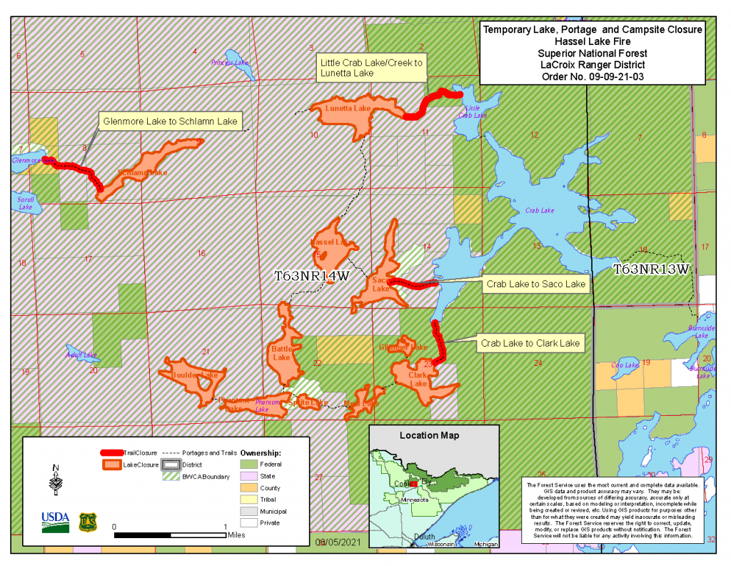
- Location: Superior National Forest within the BWCAW – southwest of Hassel Lake, approximately 16 miles northeast of Tower, Minnesota
- Incident Management Team: MNICS Team B, Incident Commander Nick Petrack
- Cooperating agencies: USDA Forest Service, Minnesota DNR, St. Louis County Emergency Management
Late in the day of June 4, a wildfire was detected southwest of Hassel Lake, within the BWCAW on the Superior National Forest. The fire was located, approximately 16 miles northeast of Tower, Minn. The cause of the Hassel fire was determined to be a result of a lightning strike.
The fire was initially estimated to be two acres in size with moderate fire activity within the Boreal Forest, including aspen, pine, and balsam fir tree species.
Due to the remote location of the Hassel fire, it was inaccessible by lakes or portages, making initial access on the ground extremely difficult and unsafe for ground firefighters. Several Fire Boss air tankers were ordered and made several drops of water throughout the first day in the attempt to slow the fire spread. As fire managers developed a suppression strategy, aircraft remained assigned to the fire to continue support with water drops. The Superior National Forest had already been maintaining additional crews and engines on the forest in anticipation of a busy spring prescribed fire and wildfire season and had a 20-person Wyoming Hotshot Crew and wildland fire engines with firefighters from several other national forests temporarily stationed on the forest to provide support for wildfire response.
The fire’s remoteness and proximity to several small Wilderness lakes that visitors used in the area prompted the Superior National Forest to establish a temporary Forest Closure Order on June 5, as a preventative measure for public safety.
Ground firefighters were transported into the fire by aircraft on June 6 and began scouting the fire for a possible access route from Boulder Lake to the fire area.
Fire activity had remained minimal until June 7, when near critical fire weather conditions set in, and late in the day fire activity picked up increasing the fire to 21-acres. Several aerial water drop cycles were ordered using the Fire Boss and CL-415 water scooping airplanes along with helicopter bucket water drops.
The Superior National Forest made the decision on June 8 to order a MNICS Type 3 Incident Management Team. MNICS Team B, led by Incident Commander Nick Petrack and the Team took command of the fire on June 9. With the team in place, additional pumps, hoses and supporting equipment were ordered, delivered, and set up at strategic areas along the fire. Aircraft continued to support ground efforts with water drops to cool off areas of heat. Food for fire crews camping in the Wilderness was coordinated through the team’s logistical support. The fire was determined to be 100 percent contained on June 11, which meant a full containment line around the perimeter of the fire was in place that would keep the fire from spreading further. MNICS Team B transitioned the management of the fire back to the Superior National Forest at the end of shift on June 11, and the fire was placed in monitor status. An incident commander for the West Zone Fire organization remained assigned to patrol and monitor the fire, which was completed by observation aircraft flights over the fire.