Skip to content
  • HOME
  • ABOUT MNICS
  • ABOUT MIFC
  • CONTACT US

MNICS.org

  • INCIDENT INFORMATION
    • Minnesota Incidents
    • Inciweb
  • SERVICES
    • Member Support
    • Weather
    • Fuels / Fire Danger
    • Outlooks
    • Firewise Minnesota
  • MNCC DISPATCH / NEK
    • Minnesota Interagency Coordination Center
    • Aviation
    • Intelligence
    • Equipment / Supplies
    • Overhead / Teams
    • Crews
    • FORMS, GUIDES AND PLANS
    • Resource Statusing Page
  • ADMINISTRATIVE
    • MNICS Coordination
    • Outreach Resources
    • Policy, Plans and Guides
    • Incident Business
    • Forms
    • Safety Management
    • Training
  • RESOURCES AND LINKS
    • Photo Galleries
    • Eastern Area Coordination Center
    • All Regional Coordination Centers
    • National Coordination Center
  • Calendar
MNICS.org

2012 Aitkin Flood

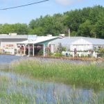
Sandbags keep a flooded street near a flower shop in Aitkin, MN in check.
Water in swollen river reaches the bottom of the Ripple River Bridge near a railroad crossing in Aitkin, MN.
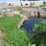
Water in swollen river reaches the bottom of the Ripple River Bridge.
Sandbags about three feet high protect Hudrliks Carpet in Aitkin, MN during the 2012 floods.
Sandbags protect Hudrliks Carpet in Aitkin, MN from flood waters.
Flooding occurs near a foot bridge in Aitkin City Park, 2012.
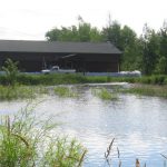
Water floods Aitkin City Park.
Flood waters breach dikes and sandbags around a local business in Aitkin, MN, 2012.
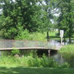
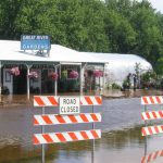
Dikes and sandbags fail near local Aitkin business.
Sandbags protect Aitkin water, sewer plant, 2012
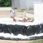
Sandbags around Aitkin water, sewer plant

Share this:

  • Click to print (Opens in new window) Print
  • Click to email a link to a friend (Opens in new window) Email

News

  • Jenkins Creek Fire and Horse River Fire Update May 30, 2025
  • Camp House Fire Final Update May 29, 2025
  • Camp House and Jenkins Creek Fire Updates May 27, 2025

Current Preparedness Levels

  • Minnesota = 3
  • Eastern Area = 2
  • National = 2

Updated 5/27/2025

NIFC Predictive Services

National Significant Wildfire Potential Outlook
MN Fire Danger map

Current Conditions

Fire Danger

MN Fire Danger map

Facebook

Facebook
  • BIA
  • DNR
  • FS
  • FWS
  • HSEM
  • NPS
  • SFM
  • |
  • DISCLAIMER
  • ADMIN LOGIN
  • PRIVACY
  • CONTACT US
 

Loading Comments...
 

You must be logged in to post a comment.