The West Zone Complex was a series of Fires that developed throughout the month of July. The first round of fires initiated after a storm system moved through the Superior National Forest near Ely, Minn., on July 6, producing significant lightning activity. On July 7, 2021 the Delta Lake, and Astray fires were reported. A day later it was determined that a previous fire, the Hassel Lake Fire had flared again, along with another new start, the Picketts Lake fire. Of the four fires, the Delta Lake fire, burning in heavy blowdown and spruce budworm killed balsam fir, proved to be the fire that required the highest level of suppression and mop-up attention.
Delta Lake Fire Summary
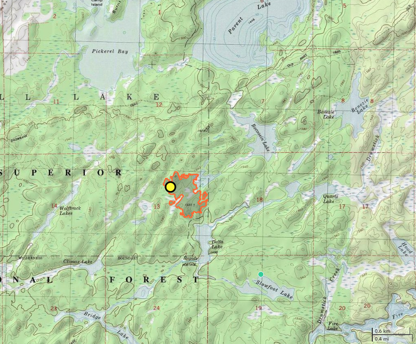
- Size: 62 acres
- Detected: July 7, 2021
- Location: Superior National Forest, 19 miles east of Ely, Minn.
- Incident Management Teams:
- MNICS Team C, Jim Edgar, Incident Commander (7/10 – 7/12)
- Eastern Area Type 2 Silver Team, Steve Goldman, Incident Commander (7/12 – 7/25)
- MNICS Team B, Tom Roach, Incident Commander (7/25- 8/6)
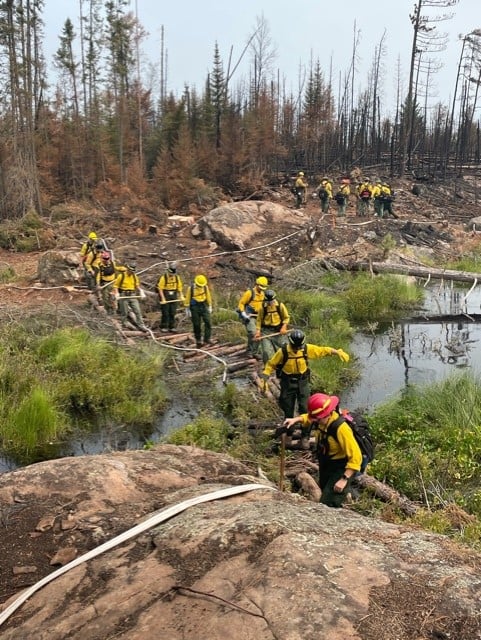
Upon initial attack stage, aircraft proved vital to dropping cooling water on advancing flames of the Delta Lake Fire, as safe access for ground firefighters into the remote areas of the Boundary Waters Canoe Area Wilderness (BWCAW) proved challenging. The Superior National Forest made the decision to order a MNICS Type 3 Team. On July 10, MNICS Team C, led by Incident Commander Jim Edgar, assumed management of the fire. That day fire weather conditions increased resulting in higher fire activity and spotting.
Due to the proximity of the Delta Lake Fire to recreation sites and private cabins, structure protection was necessary. While structure protections plans were being developed, fire crews from Pennsylvania and Connecticut began work on establishing safe access into the fire. Air resources continued to provide cooling water drops on active flames, helping support ground efforts.
Concerns were growing about seven wildfires burning north of the BWCAW in Canada’s Quetico Provincial Park. Two of the fires were in close enough proximity to the international border, the threat of them breaching into the BWCAW became a grave concern and daily flights to monitor the progression of the Canada wildfires occurred.
On July 11, the Superior National Forest and MNICS Team C recognized the growing complexity involved with the Delta Lake fire, and the Canada wildfires and the decision was made to order an Eastern Area (EA) Type 2 Incident Management Team. The EA Silver Team, led by Incident Commander Steve Goldman, arrived on July 12, in-briefed with MNICS Team C, and transitioned into management the following day. Fire crews began the arduous process of constructing containment line, and structures crews began staging pumps, sprinklers, and hose at structures nearest the fire’s edge.
Fire crews covered nearly 2/3 of the containment line with saws and hose lay by July 14, and the mop up process began. In total, nearly four miles of hose line was established around the Delta Lake Fire. The EA Silver Team continued to focus on monitoring the behavior and movement of the Canada wildfire nearest the border and honing contingency plans.
The Delta Lake fire was reported 85 percent contained on July 25. That day, the EA Silver Team transitioned management of the Delta Lake fire and the West Zone Complex to MNICS Type 3 Team B, led by Incident Commander Tom Roach. Fire crews began the process of hauling sprinkler systems, hoses, and pumps out of areas near the fire that were secured with contingency lines. The Delta Lake fire reached 100 percent containment on July 31. Fire crews began the long process of breaking down hose lay and prepared for back hauling of equipment off the fire line. MNICS Team B remained in command of the fire through August 6, when they returned management of the Delta Lake fire back to the Superior National Forest.